
Fájl:City of London map 01.jpg
Az előnézet mérete: 773 × 600 képpont További felbontások: 309 × 240 képpont | 619 × 480 képpont | 990 × 768 képpont | 1 280 × 993 képpont | 2 560 × 1 987 képpont | 4 778 × 3 708 képpont.
Eredeti fájl (4 778 × 3 708 képpont, fájlméret: 815 KB, MIME-típus: image/jpeg)
|
Ez a fájl a Wikimedia Commonsból származik. Az alább látható leírás az ottani dokumentációjának másolata. A Commons projekt szabad licencű kép- és multimédiatár. Segíts te is az építésében! |
Összefoglaló

|
Ez a kép elérhető vektorgrafikus (SVG) változatban is. Ha jobb minőségű, azt használd e helyett a raszterkép helyett.
File:City of London map 01.jpg → File:City of London map 01.svg
A vektorgrafikáról a Help:SVG oldalon találsz információkat. |
 |
| Leírás |
Català: Límits de la Ciutat de Londres en blau i els límits anteriors al 1993 en vermell.
Deutsch: Ausdehnung der City of London; die Grenze vor 1993 ist rot markiert, der Inner Temple und der Middle Temple grün.
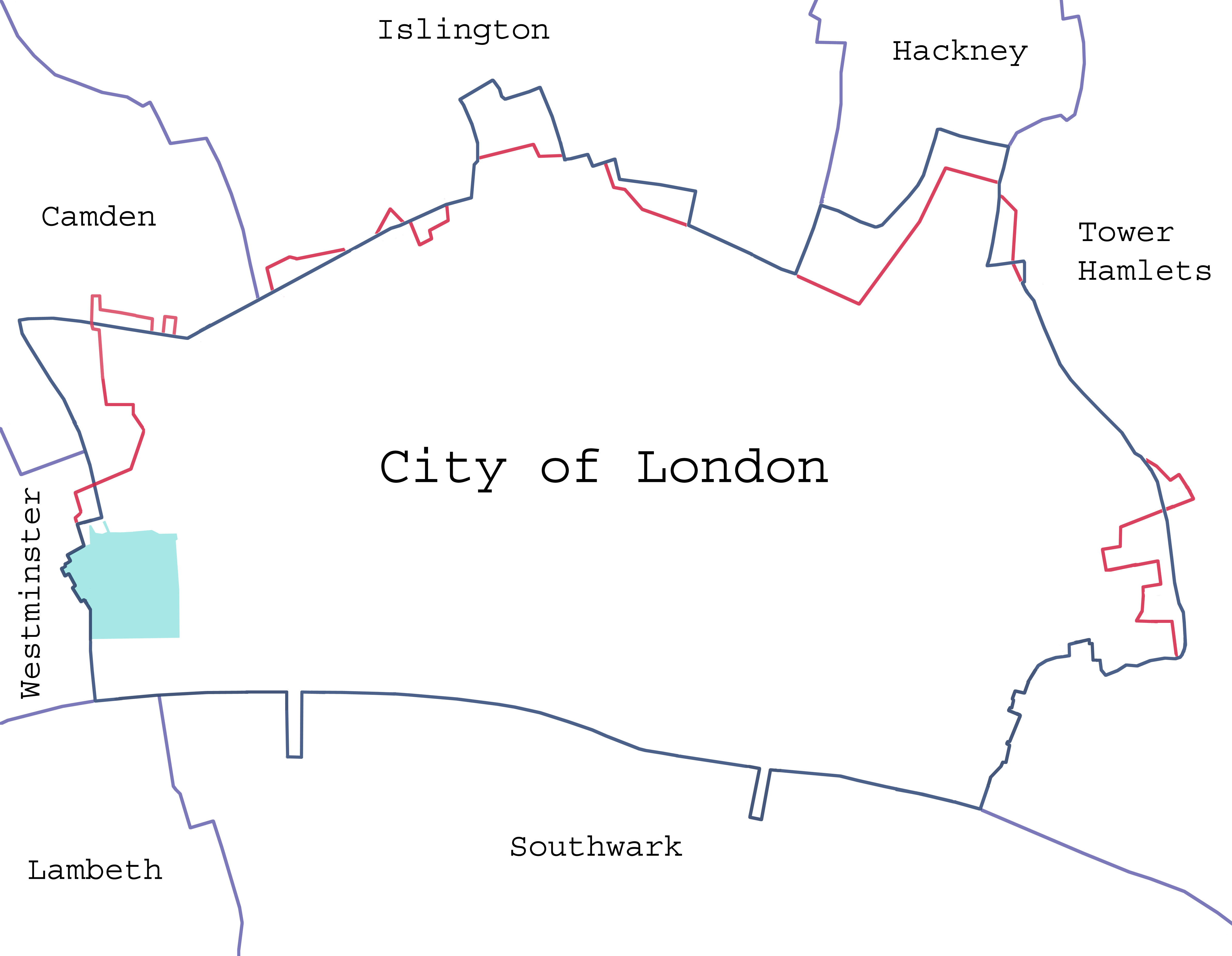
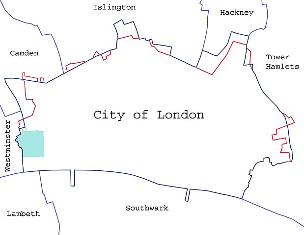
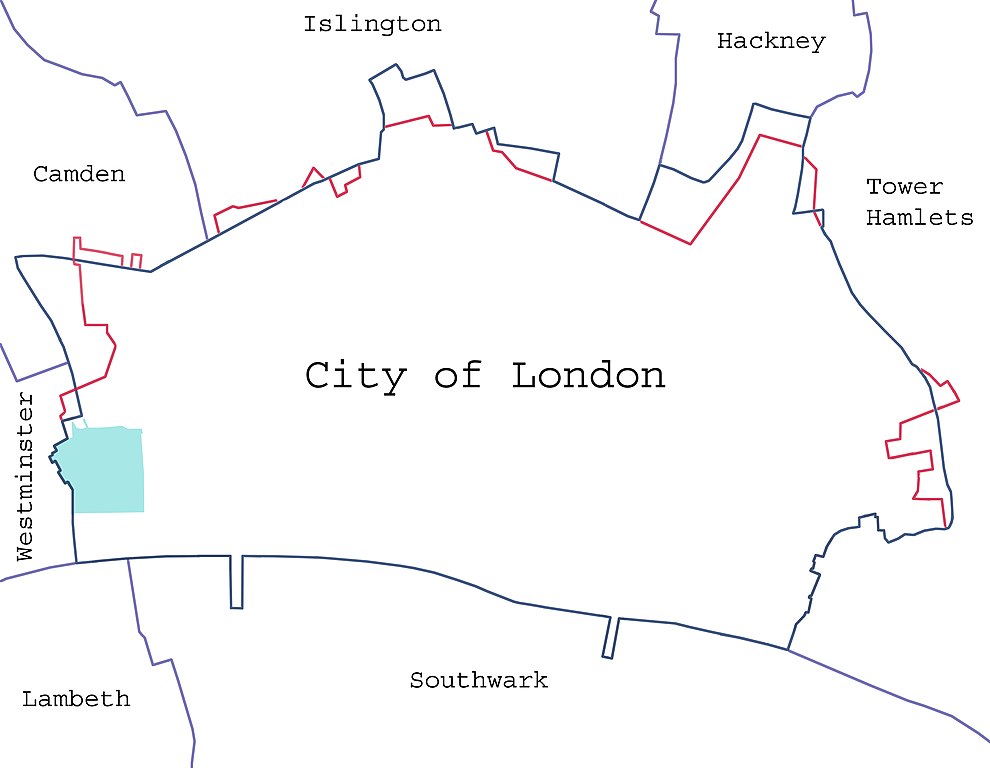
English: Borders of the City of London, showing surrounding London boroughs and the pre-1994 boundary (where changed). The area covered by the Inner and Middle Temple is marked.
Español: Límites de la City.
Magyar: A City jelenlegi és 1993. előtti határai, szomszédos kerületei. Az Inner és Middle Temple által elfoglalt területeket is jelzi a térkép. English: Map of the en:City of London, showing surrounding London Boroughs and the pre-1993 boundary (where changed) in red. The area covered by the Inner and Middle Temples is shown in light green. |
| Dátum |
2008. január 23. (eredeti feltöltésének dátuma) |
| Forrás | A feltöltő saját munkája (Eredeti szöveg: „self-made”) |
| Szerző |
Dpaajones a(z) angol Wikipédia projektből |
| Engedély (Fájl újrafelhasználása) |
Yes; note that the map has been created with data from en:Ordnance Survey. |
Licenc
Dpaajones a(z) angol Wikipédia projektből, e mű szerzője a művét az alábbi licencek alatt teszi közzé:

|
Ez a fájl szabadon másolható, terjeszthető és/vagy módosítható a GNU Szabad Dokumentációs Licenc feltételei alapján, az 1.2 vagy későbbi, a Free Software Foundation által publikált Nem Változtatható szakaszok, Címlapszövegek és Hátlapszövegek nélküli változat szerint. E licenc egy példánya a GNU Szabad Dokumentációs Licenc című fejezetben olvasható. |
Ez a fájl a Creative Commons Nevezd meg! – Így add tovább! 3.0 Unported, 2.5 Általános, 2.0 Általános és 1.0 Általános licencek alapján használható fel.
Így nevezd meg: Dpaajones a(z) angol Wikipédia projektből
- A következőket teheted a művel:
- megoszthatod – szabadon másolhatod, terjesztheted, bemutathatod és előadhatod a művet
- feldolgozhatod – származékos műveket hozhatsz létre
- Az alábbi feltételekkel:
- Nevezd meg! – A szerzőt megfelelően fel kell tüntetned, hivatkozást kell létrehoznod a licencre és jelezned kell, ha a művön változtatást hajtottál végre. Ezt bármilyen észszerű módon megteheted, kivéve oly módon, ami azt sugallná hogy a jogosult támogat téged vagy a felhasználásod körülményeit.
- Így add tovább! – Ha megváltoztatod, átalakítod, feldolgozod ezt a művet, a közreműködésedet csak az eredetivel megegyező vagy hasonló licenc alatt terjesztheted.
A mű a fenti licencek bármelyike szerint felhasználható.
Eredeti feltöltési napló
Az eredeti leírólap itt volt. Az itt következő felhasználónevek az en.wikipedia projektre hivatkoznak.
- 2008-01-24 14:20 Dpaajones 4778×3708×8 (834539 bytes) {{Information |Description=Map of the [[City of London]], showing surrounding London Boroughs and the pre-1993 boundary (where changed) in red. The area coverd by the Inner and Middle Temples is shown in light green. |Source=self-made |Date=January 2008 |
- 2008-01-24 14:16 Dpaajones 4778×3708×8 (834539 bytes) {{Information |Description=Map of the [[City of London]], showing surrounding London Boroughs and the pre-1993 boundary (where changed) in red. The area coverd by the Inner and Middle Temples is shown in light green. |Source=self-made |Date=January 2008 |
- 2008-01-23 22:38 Dpaajones 4778×3708×8 (828891 bytes) {{Information |Description=Map of the [[City of London]], showing surrounding London Boroughs and the pre-1993 boundary (where changed) |Source=self-made |Date=January 2008 |Location=City of London, London |Author=Mr David Philip Jones |Permission=yes |ot
Fájltörténet
Kattints egy időpontra, hogy a fájl akkori állapotát láthasd.
| Dátum/idő | Bélyegkép | Felbontás | Feltöltő | Megjegyzés | |
|---|---|---|---|---|---|
| aktuális | 2008. február 7., 00:44 | | 4 778 × 3 708 (815 KB) | Pacoperez6 | {{Information |Description={{en|Map of the en:City of London, showing surrounding London Boroughs and the pre-1993 boundary (where changed) in red. The area covered by the Inner and Middle Temples is shown in light green.}} |Source=Transferred from [ |
Fájlhasználat
Az alábbi lap használja ezt a fájlt:
Globális fájlhasználat
A következő wikik használják ezt a fájlt:
- Használata itt: ca.wikipedia.org
- Használata itt: es.wikipedia.org